Within the proposed park boundary is approximately 5,000 acres of government owned land which is either crown land, provincial or federal wildlife areas. In other words, this land is already being used for conservation. Just as the Thousand Islands and Bruce Peninsula National Park boundary includes privately owned land within the park boundary, the same would be true for the Point to Point's proposal. Sandbanks and Algonquin Provincial Parks are two other examples of private land within a park boundary.
Private landowners may choose be involved with a land stewardship program if they are interested.
We are seeing more and more communities partnering with conservation initiatives. Some examples include Algonquin to Adirondacks Conservation Association (A2A) and the Bruce Trail. Both of these examples show how private landowners may choose to become involved.
Maps
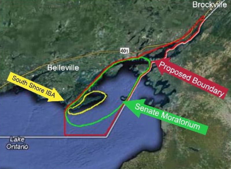
Proposed park boundary
Parks Canada suggested having the park boundary extend to the U.S. border. It could blend into to the Thousand Island National Park or be a separate entity.
Proposed park boundary
Parks Canada suggested having the park boundary extend to the U.S. border. It could blend into to the Thousand Island National Park or be a separate entity.
Government land within the South Shore of PEC
This would include the False and Main Duck Islands. Main Duck Island (not shown on this map) and the Lighthouse at Point Traverse are currently part of the Thousand Island's National Park.